Rio Usumacinta

contenido
- Regresa el fantasma del Usumacinta
- Expedición por el Usumacinta
- Indigene Gemeinden sind wegen Hydro-Elektrischer Arbeit dem Risiko ausgesetzt, vertrieben zu werden
- Indagarán diputados la hidroeléctrica del Usumacinta
- Usumacinta River Guide
- The Threat of Dams and Flooding to Archaeological Sites
- Govts. set interconnection schedule
- map (I) maps (II)
enlaces
The Threat of Dams and Flooding to Archaeological Sites along the Usumacinta River
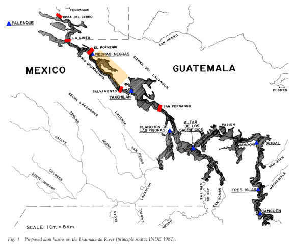
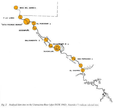
 The Usumacinta River Basin covers an expansive area that includes much of Guatemala and Southern Mexico. For several decades now, various plans have been put forward to harness the river's energies through a series of dams placed along its middle route, where it forms the border between the Mexican state of Chiapas and the Guatemalan department of the Peten. These plans appeared to have been shelved by the Mexican government in 1991 (Wilkerson 2001). However, recent reports from periodicals suggest that the plan has been revived, and that dam construction may go forward. Although most observers recognize the potential economic value of producing hydroelectric power on the Usumacinta, the cost to the cultural patrimony of Guatemala and Mexico is unknown.
We know that we would lose much of Piedras Negras and Altar de Sacraficios in Guatemala, as well as large portions of Yaxchilan in Mexico to the rising river behind the dams. This in and of itself would be a catastrophic loss to the patrimony of these two countries. But in truth, no scientific survey of archaeological sites has been undertaken along much of the river's course, and the low, swampy areas that form large portions of the Sierra del Lacandon National Park in Guatemala are among the regions in most serious threat should the waters rise. Should dam construction take place before a thorough archaeological survey can be completed, we will never know what was lost.
Based on the available data regarding dam construction location and projected levels of flooding, the large urban center of Piedras Negras would become a set of islands and peninsulas jutting out into the river. Those areas that remained above water are the most thoroughly studied, and those areas that would be inundated still require investigation.
The site of Yaxchilan in Mexico would also be gravely affected by the rising water levels. Despite a long history of archaeological research in the site core, much remains to be discovered about Yaxchilan. This ancient royal center, a favorite of modern tourists, would lose many of the fine palaces that attract visitors.
It is not the role of archaeologists to make government policies. But we can help to assess the potential threat to the cultural patrimony of Guatemala and Mexico, and help weigh the costs and benefits of any given development project in an archaeologically and environmentally sensitive area such as the Sierra del Lacandon. One of the primary goals of the Sierra del Lacandon Regional Archaeology survey is to provide a thorough and accurate assessment of the threat of flooding to the archaeological sites along the Usumacinta.
For Further Reading
Wilkerson, S. Jeffrey K.
2001 Usumacinta River Dam Project
In Archaeology of Ancient Mexico and Central America: An Encyclopedia.
Susan T. Evans and David L. Webster eds. pp. 791 - 792. Garland, New York.
Wilkerson, S. Jeffrey K.
1991 Damming the Usumacinta: The Archaeological Impact
In 6th Palenque Round Table, 1986. Virginia M. Fields, ed.
pp. 118 - 134. University of Oklahoma Press, Norman.
Wilkerson, S. Jeffrey K.
1985 The Usumacinta River: Troubles on a wild frontier
National Geographic 168(4):514 - 543.
Wilkerson, S. Jeffrey K.
1984 Mexico and Guatemala: Archaeological and ecological implications of proposesd hydroelectric projects on the Rio Usumacinta
IWGIA Newsletter 38:75 - 89.
Websites
The following websites represent a diverse group of organizations reporting on various aspects of the proposed Usumacinta dam project. The opinions expressed on these websites are not necessarily those of the project members of the SLRAP.
Reforma.com, an on-line periodical from Mexico.
Global Exchange, a human rights organization.
CIEPAC: Centro de Investigaciones Economicas y Politicas de Accion Communitaria, a civil action group in Chiapas, Mexico.
The Usumacinta River: Building a Framework for Cooperation Between Mexico and Guatemala,"from The Center for Governmental Responsibility at the University of Florida's Levin College of Law
From PARI's Mesoweb, insight from archaeologists at Palenque, Chiapas, Mexico.
A note in the September issue of Archaeology Magazine concerning several issues affecting archaeolgical sites in the Mundo Maya.
From "Mexico Tercer Milenio," the perspective is one of economic growth that ignores the impact on cultural patrimony, and puts a 'positive' spin on the inundation of forested areas.
The International Rivers Network, a group that links human rights to environmental protection of rivers and their watersheds.
Information on Ecotourism and the Usumacinta River from Planeta.com.
Detailed information on the Plan Puebla-Panama, of which proposed dams are a component, from the Bank Information Center.
More details on the PPP from the government of Mexico.
News article from on-line magazine Americas.org.
Information is also being distributed via The Daily Glyph on-line magazine.
Plan Puebla Panama | Dam Protests | Water Campaign | www.agp.org (archives) | www.all4all.org


